Friday, November 23, 2012

Port Of Callao, Peru

The Port of Callao is Peru's main commercial seaport. Just 12 kilometers from downtown Lima (Spanish), the country's capital, the Port of Callao is part of the Lima-Callao metropolitan area. The Port of Callaois 765 kilometers northwest of Peru's southern Port of Matarani and 960 kilometers southwest of the relatively isolated Port of Iquitos on the Amazon River in the country's far northeast region. The Port of Callao has one of South America's few good natural harbors on the Pacific Ocean. In 2005, almost 390 thousand people lived in the Port of Callao, although the Lima-Callao metropolitan area is home to more than 8.4 million.

The Port of Callao lies south of the Rimac River at the tip of a peninsula protected by the offshore island of San Lorenzo and a promontory. The Port of Callao exports mainly refined metals, minerals, fish meal, and fish oil. Its principal imports are wheat, lumber, and machinery. The Port of Callao is home to a wide range of industries that include breweries, fish meal factories, and shipbuilding yards. The Port of Callao is also home to a large naval base and the Jorge Chavez International Airport. It is also the site of several islands that support a large colony of sea lions and seabirds in a relatively pristine ecosystem.

Peru's National Port Authority (Spanish) (APN) governs all ports in Peru, including the Port of Callao. The Empresa Nacional de Puertos S.A. (ENAPU) was created by law in 1970 as a decentralized public organization under the Transports and Communications Sector. ENAPU was made responsible for operating, maintaining, and administering all terminals and jetties in the Republic of Peru.

ENAPU seeks to be the leading container port on South America's Pacific Coast, and the Port of Callao plays a vital role in that leadership. Both competing and cooperating with the private sector, ENAPU provides appropriate port infrastructure, modern equipment, and skilled workers to offer the best port services available. ENAPU is committed to meeting the demands for port services effectively, efficiently, and reliably to support the development of foreign trade in Peru and the integration of the Port of Callao-Lima region.


La Empresa Nacional de Puertos ENAPU S.A. administers and develops the Port of Callao under state ownership. The Port of Callao serves a vast hinterland that contains Lima, Huanuco, Cerro de Pasco, Ayacucho, Huancavelica, and Junin. Located in the Pacific Basin on Peru's central coast, the Port of Callao holds an important strategic position on the inter-oceanic routes for vessels crossing the Panama Canal and the Straits of Magellan.

The Port of Callao serves Peru's capital city of Lima and the rest of the country through a network of roads that extend to the north and south and into the central mountain region. The Port of Callao is connected by road with the Jorge Chavez International Airport, located about four kilometers northeast of the Port of Callao, and to the nation's railroad that crosses the Andes Mountain range.

Saturday, November 17, 2012

Port Of Auckland, New Zealand


The Ports of Auckland is on the North Island of New Zealand. Ports of Auckland is located some 345 kilometers northwest of the Port of Napier and over 500 kilometers north of the Port of Wellington, two other ports on the North Island. Auckland is New Zealand's largest city and seaport. It is one of few cities with harbors on two different water bodies. The Ports of Auckland rests on a narrow strip of land between Waitemata Harbor to the east and Manukau Harbor to the southwest. In 2006, over 404 thousand people lived in the city of Auckland, and over 1.2 million called the urban area home.

The Ports of Auckland is the economic center of New Zealand, and most large international corporations have offices there. Its central business district contains many financial and business service companies, while the industrial and commercial zones are located in South Auckland along the Tamaki River estuary and the Manukau Harbour. The Ports of Auckland is a hub of road and rail transportation, and it is home to the country's main international airport. The Ports of Auckland area contains important engineering and publishing companies, and its manufacturers produce glass, paint, plastics, cement, and a host of consumer goods. Food processing, sugar refining, and brewing are important to the local economy, as are vehicle assembly and shipbuilding.

In 1863, the worst maritime disaster in the history of New Zealand made clear the limitations of the Ports of Auckland's Onehunga port. A 1700-ton steam corvette, the HMS Orpheus, struck the Manukau Bar at 1:30 in the afternoon. By 9pm, the mast disappeared below the water surface. Out of 250 passengers, only 70 survived.

In 1871, the Auckland Harbour Board was established by an act of Parliament. An elected board and a permanent staff administered the Ports of Auckland. In 1875, an act of Parliament gave the Board more than two thousand hectares of the seabed in Waitemata Harbor.

As cargo volume increased, the Board made significant improvements to the Ports of Auckland including reclaiming lands on Auckland's foreshore. Better Ports of Auckland dockyards were established, and a new railway wharf was added. By the end of the 19th Century, the Ports of Auckland was also a busy passenger port with travelers bound for Sydney, San Francisco, and London.

In the early 20th Century, developments were completed between the modern Princes Wharf and Kings Wharf in the Ports of Auckland. In 1913, the Auckland Harbour Board became responsible for the management and operation of the Manukau Harbour and the Onehunga Port. Within the Auckland area, the wooden Queen Street Wharf was replaced by concrete, and the Marsden Wharf was completed. The Ports of Auckland's Captain Cook Wharf opened in 1922. The Prince of Wales visited Auckland in 1921, and the Princes Wharf was completed in 1923. By 1931, the Western Reclamation and Western Wharf extension were finished.

During World War II, part of the United States' Pacific fleet was based in the Ports of Auckland. Over 100 warships and 280 transporters called at the Ports of Auckland in 1943, and the need for more storage facilities became apparent. The Ports of Auckland engaged in near-constant reclamation work to cope with the increasing demand.

In 1948, the Bledisloe Wharf in the Ports of Auckland was opened to handle frozen cargoes for export. In the 1950s, cargo volumes moving through the Onehunga port increased, and the growth continued into the mid-1960s. Dedicated to imports, Auckland's Jellicoe Wharf was finished in 1952, and the Freyberg Wharf was completed in 1961.

During the 1960s and 1970s, the shipping industry went through major changes as new technology and machines replaced labor-intensive operations. Containerization was revolutionary. In 1971, the Ports of Auckland's Fergusson Container Terminal was built to handle containers, and the Bledisloe Wharf was converted for containerized cargoes. In 1971, the Columbus New Zealand, called at the Ports of Auckland Fergusson container terminal and was unloaded using the first ship-to-shore container crane in the country. The Onehunga port began handling containers in 1982.

In 1988, New Zealand's Parliament passed legislation to change the structure of port management. Ports of Auckland Limited was formed, and it purchased the land and assets of the Auckland Harbour Board and took over commercial port operations. Listed on the New Zealand Stock Exchange, the Auckland Regional Authority owned 80% of the shares, and the Waikato Regional Council owned 20%. During its first years, the Ports of Auckland increased efficiency and productivity dramatically.

The Ports of Auckland has continued to work to improve productivity and efficiency since the early 1990s, and capacity has continued to increase. New container cranes were added in 2001 and 2006, and the Ports of Auckland has focused on rail and supply chain solutions. In 2002, the first inland port at East Tamaki was opened by the Ports of Auckland. In 2005, the Ports of Auckland opened another inland port at Wiri in South Auckland.

The Ports of Auckland has continued to do reclamation work at the Fergusson Container Terminal. In 2003, efforts began to deepen the shipping lane and to expand the terminal by 9.5 hectares. The new shipping lane opened in 2007, and the first phase of the terminal extension was finished in 2007.

Ports of Auckland has also been moving gradually towards the east, opening over 70 hectares of land to alternative uses since 1996. In 2007, the land in the Western Reclamation was transferred to the Wynyard Quarter redevelopment. Ports of Auckland Limited was delisted from the Stock Exchange in 2005, and Auckland Regional Holdings, an arm of the Auckland Regional Council, owns 100% of the company today. Profits are reinvested in the region to support infrastructure and stormwater control projects.

Today, the Ports of Auckland is the country's biggest international container port. The Port operates 24 hours a day throughout the year and services over 1700 ship calls, 4 million tons of breakbulk cargo, and over 770 thousand TEUs of containerized cargo each year. The Ports of Auckland is responsible for ensuring an efficient supply chain for containers and developing container hub operations. Near the busy and growing industrial area of South Auckland, the Ports of Auckland continues to get a constant flow of vessels carrying coastal goods as well as the local fishing fleet.

With water area of 394 square kilometers, the Ports of Auckland's Manukau Harbour is one of the largest inlets on New Zealand's west coast. Unfortunately, navigation is limited due to the numerous tidal sand bars, including a curving sand bar that stretches across the harbor entrance, making it very narrow.

Sunday, September 16, 2012

Port Of Karachi, Pakistan

The Port of Karachi is the capital of Pakistan's Sindh Province. It is the largest city and main seaport of the country. Located about 50 kilometers west of the Port of Muhammad Bin Qasim and some 380 kilometers northwest of India's Port of Kandla. The Port of Karachi is also an important industrial and commercial center in Pakistan. In 2005, some 11.6 million people lived in the urban area of the Port of Karachi.

Karachi is Pakistan's financial and commercial capital as well, and the Port of Karachi accounts for most of the Pakistan's revenues. Some 50 banks and insurance companies are headquartered in the Port of Karachi. One of the busiest ports east of the Suez Canal, the Port of Karachi handles all of Pakistan's and Afghanistan's sea-borne trade.

The major products manufactured in the Port of Karachi are textiles and footwear, and other manufactured goods include metal products, paper, food and beverages, machinery, wood and furniture, chemicals, leather, petroleum, rubber, and electrical goods. Cottage industries in the Port of Karachi produce hand loomed cloth, carpets, lace, brass goods, pottery, and silver and gold embroidery. The Port of Karachi is linked to the interior by the Karachi-Peshawar highway and to coastal cities by the Karachi-Ormara highway. Pakistan's railway system, which terminates in the Port of Karachi, transports goods between the city and the interior, and there are many passenger trains for commuter traffic.

When the capital of British India was moved to Delhi in 1911, the Port of Karachi became more important as a gateway to India. During World War I, the Port of Karachi important as the first Indian port for ships traveling the Suez Canal and the gateway to both Afghanistan and the Russian Empire.

By 1914, the Port of Karachi's Napier Mole Boat Wharf and the East Wharves were finished. Between 1927 and 1944, the Port of Karachi gained many new facilities that included the West Wharves, lighterage berths, and ship-repair berths. Unfortunately, most of these facilities were outdated by 1947.

The Port of Karachi again served as an important military base during World War II, as it was a supply point for supplies to the Russian front. When the country of Pakistan was formed in 1947, most of the Port of Karachi's Hindu population was drive out of the country to India.

By that time, the Port of Karachi was a modern cosmopolitan city with beautiful architecture and many modern conveniences. The Port of Karachi was chosen to be the capital of Pakistan. Many new residents arrived as Muslims left India, bringing a population boom and a dramatic change in the city's culture and economy.

In 1958, the country's capital was moved to Rawalpindi and then to Islamabad in 1960. The move began a period of decline for the Port of Karachi in which little new development occurred. In the 1970s, labor struggles erupted in the Port of Karachi's industrial areas. Refugees from the Afghan War poured into the Port of Karachi in the 1980s and 1990s, and they were followed by refugees from Iran. Political tensions between native groups and the immigrants exploded in racial and political violence.

It is said that the years of 1992 through 1994 were the bloodiest time in the Port of Karachi's history. The Army conducted "Operation Clean-up" against the Mohajir Quami Movement that largely represented the 1947 immigrants.
Today, most of the older tensions have faded. The Port of Karachi retains its position as an important industrial and financial center in Pakistan, and it handles most of the country's overseas trade.

The Port of Karachi is one of the world's fastest-growing cities, and it faces the challenges of rapid growth: traffic, pollution, street crime, and poverty. These problems plague the Port of Karachi with a reputation for being a not-very-livable city. Traffic and air pollution are major problems facing the city, and the city has created new parks and planted trees in hopes of reducing pollution and improving the environment.


The Karachi Port Trust is the port authority for the Port of Karachi. It is administered by a Board of Trustees representing the public and private sectors. The Chairman of the Board, who is also the Chief Executive Officer for the Trust, is appointed by the Federal Government. The Karachi Port Trust is a federal government agency responsible for overseeing the Port of Karachi operations. The Trust was established by law in 1886.

Port Of Toronto, Canada

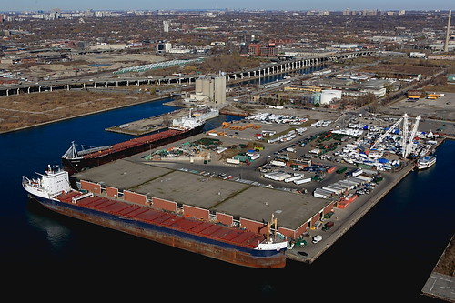
The Port of Toronto is the biggest city in Canada and the capital of the Province of Ontario. It's Canada's commercial and financial center and one of its most important ports. Located on the northern shores of Lake Ontario just 94 kilometers northwest of Buffalo, New York, it has access to the Atlantic Ocean and major US trading centers by the St. Lawrence Seaway (it's over 860 kilometers to Quebec). In 2006, the city was home to over 2.5 million people, and more than 5.1 million people called the Toronto metropolitan area home.


Today, the Port of Toronto is Canada's economic capital and one of the world's top financial centers. Its strongest economic sectors include finance, telecommunications, aerospace, business services, publishing and entertainment media, software, education, sports, medical research, and tourism.

The modern Port of Toronto is an international, cosmopolitan city and a magnet for immigrants to Canada. Almost half of the city's residents were not born in Canada. The city enjoys a low crime rate, a high standard of living, and environmental health. It has been consistently rated as one of the most livable cities in the world.


The Toronto Port Authority (TPA) manages and operates not only the Port of Toronto but the city's City Centre Airport, including its MEDVAC service. The TPA owns and operates the Outer Harbor Marina and over 50 acres of paved cargo-handling area. The Port of Toronto is next to the city's industrial, business, and cultural centers and offers direct access to highway and rail networks for the metropolitan area and for a wider market that covers Ontario, Midwest Canada, Northwestern Quebec, and the northeast U.S.

Port of Toronto operations cover over 20 hectares and include seven marine berths, an almost 14 thousand square meter marine terminal, a 100 thousand square meter container terminal with heated storage with electrical connections, and a secured paved yard.

Storage facilities at the Port of Toronto include Warehouse 52, a heated indoor area with bays for containers and rail and truck services. The paved yard, which is protected by 24-hour security, contains three sheds covering almost 21 thousand square meters and two outdoor terminals covering over than 103 square meters. Large paved container yards contain several container cranes, electric plugs for reefers, and direct access to rail services. The roll-on/roll-off dock features a fenced paved yard. In 2003, the Port of Toronto handled over 2 million tons of cargo, representing a 22% increase over the previous year.

Thursday, September 6, 2012

Port Of Alexandria, Egypt

The Port of Alexandria is the second most important city and the main seaport for Egypt. The Port of Alexandria stretches for 40 kilometers along a limestone ridge on the shores of the Mediterranean Sea. The Port of Alexandria is about six kilometers northeast of the Port of El-Dekheila, managed by the same port authority, and 26 kilometers west of the Port of Abu Qir. The Port of Alexandria is also about 180 kilometers northwest of Egypt's capital of Cairo. The Port of Alexandria is linked by road, rail, and air to other cities in Egypt and by canal with the Nile River. In 2006, over 4.1 million people lived in the Port of Alexandria's metropolitan area.

The Port of Alexandria's economy is based on the seaport, industrial and commercial activity, and agriculture. Shipping, manufacturing, banking, food processing, and the manufacture of cement and petrochemicals are important to the national economy. The Port of Alexandria makes up about two-fifths of the country's industrial output. The Mina al-Basal area around the Port of Alexandria contains many warehouses. Once home to the Cotton Exchange, the Mina Al-Basal now houses rice and paper mills, asphalt works, salt and tanning factories, a cement works, and an oil refinery. To the south are more oil refineries. Agricultural production is also important to the local economy and, although cotton is not as important as it was in the 19th Century, food production employs many workers in the Port of Alexandria area.


The Port of Alexandria (Al-Iskandariyah) was the greatest city in the ancient world. Now, it's the second largest city and the major seaport for Egypt. Situated at the western edge of the Nile River delta, it's some 180 kilometers northwest of Cairo.

Founded by Alexander the Great in 332 BC, it was the center for Greek science and scholarship until 642 AD when it was conquered by the Arabs. Alexander built the city on the 1500 BC site of Rakotis. When Alexander conquered Tyre in 332 BC, the Port of Alexandria profited from the destruction of the Phoenician's power and from trade with Europe. Many scholars studied there, including Archimedes and Euclid, and the Port of Alexandria was also a center of Jewish scholarship. Upon Alexander's death in 323 BC, rule passed to Pharaoh Ptolemy I who presided over the city's golden age.

The rise of Rome in the 2nd and 1st Centuries BC paralleled the decline of Ptolemaic rule. In fact, the Port of Alexandria was involved in the establishment of imperial Rome. Cleopatra, the last Ptolemy, seduced both Julius Caesar and Marc Antony in her unsuccessful efforts to restore Egyptian power. In 30 BC, Caesar's great-nephew Octavian brought the Port of Alexandria and all of Egypt under Roman rule, including destroying the great Library of Alexandria. Because the Port of Alexandria contained the Egyptian granary that Rome needed, the city regained much autonomy.

Greek culture in the Port of Alexandria began a rapid decline after 415 AD. Alexandria fell to the Persians in 616 AD and to the Arabs in 642 AD. After that time, Alexandrian culture and life reflected the new Muslim faith and culture. Despite declining political influence, the Port of Alexandria continued to be an important trading center for textiles and other luxury goods.

Luckily, the Port of Alexandria came through the early Christian Crusades relatively undamaged, and it played a major role in Egypt's east-west spice trade. However, the discovery of a sea route to India (1498) and Turkey's conquest of Egypt (1517) brought an end to Alexandria's good fortune. By 1798 when Napoleon invaded Egypt, the Port of Alexandria had become a small fishing village.

The Port of Alexandria's rebirth came in 1805 when Muhammad Ali became Ottoman viceroy of Egypt. He sought to modernize Egypt, and he reopened access to the Nile for the Port of Alexandria with the 45-mile Al-Mahmudiyah Canal (1820). He built new docks and an arsenal there between 1828 and 1833, and he located industry in the Port of Alexandria.
After cotton was introduced to Egypt, Europe's hunger for the product brought great wealth to the Port of Alexandria. The Port of Alexandria's importance as a commercial and banking center grew. Then with the American Civil War creating a new cotton boom in the early 1860s and the Suez Canal opening in 1869, the Port of Alexandria enjoyed yet another period of rapid growth.

In 1882, the British occupied the Port of Alexandria to put down local revolt, and they stayed there until 1922. While the British ruled, foreign residents increased to about 100 thousand people, and the city continued to grow. The Port of Alexandria was the Allies' major naval base for the Mediterranean during World War I, and it was almost captured by Axis troops during World War II. The British military finally left the Port of Alexandria in 1946.

In 1952, King Farouk escaped Egypt through the Port of Alexandria. During the 1960s, Alexandria came under the strong control of Egypt's government and was completely "Egyptianized." Abdel Nasser's industrialization effort benefited the Port of Alexandria, particularly in the textile manufacturing and food processing industries.

Egypt's defeat in the 1967 Six-Day War with Israel led to the Port of Alexandria being overwhelmed by trade when the Suez Canal was closed and Egypt evacuated the Canal Zone. Then in 1974, Egypt adopted an open-door trade policy, and the port was again flooded with imported goods.

In the latter 1970s, liberalization and decentralization under Anwar el-Sadat led to the Port of Alexandria's greater financial autonomy and new local pride. Natural gas was discovered, a new iron and steel industry sprang up nearby, oil refineries were updated, a pipeline for crude oil linked the Port of Alexandria of Suez to the Mediterranean near the Port of Alexandria, and a second pipeline linked Cairo to Alexandria. Light industry began to grow there as well.