
The Port of New York and New Jersey comprises the waterways in the estuary of the New York-Newark metropolitan area with a port district encompassing an approximate area within a 25-mile (40 km) radius of the Statue of Liberty National Monument. The system of navigable waters along 650 miles (1,050 km) of shoreline in the vicinity of New York City and northeastern New Jersey is considered one the finest natural harbors in the world. The port is by tonnage the third largest in the United States and the busiest on the East
The Atlantic Ocean is to the southeast. The sea at the entrance to the port is called the New York Bight which lies between the peninsulas of Sandy Hook and Rockaway. In Lower New York Bay and its western arm Raritan Bay, ocean-going vessels orient themselves for passage to the east into Arthur Kill or to the north to The Narrows. To the east lies the Rockaway Inlet which leads to Jamaica Bay. Sometimes called by the name of the bridge which spans it, the Verrazano Narrows strait connects to the Upper New York Bay. Traditionally called New York Harbor, the Upper Bay lies at the mouth of the Hudson River which is sometimes called, particularly in navigation, the North River.Port of Albany-Rensselaer. To the west lies Kill van Kull, the strait leading to Newark Bay, fed by the Passaic River and Hackensack River, and the northern entrance of Arthur Kill. The Gowanus Canal and Buttermilk Channel are entered from the east. The East River is a broad strait which travels north to Newtown Creek and the Harlem River, turning east at Hell Gate before opening to Long Island Sound, which provides an outlet to the open sea.
 Large ships are able to travel upstream to the
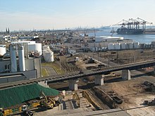
 There are four container terminals in the port, the combined volume of which makes it the largest on the East Coast, third busiest in the United States,and 20th world-wide. Terminals are leased to different port operators, such as A. P. Moller-Maersk Group, American Stevedoring,NYCT and Global Marine Terminal
- Howland Hook Marine Terminal
- Port Jersey Marine Terminal
- Port Newark-Elizabeth Marine Terminal, the nation's first and third busiest
- Red Hook Marine Terminal
No comments:
Post a Comment