Sunday, December 18, 2011

Port Of Tokyo, Japan


The Port of Tokyo lies at the head of Tokyo Bay on Honshu Island's Pacific coast. It is the biggest industrial and urban area in Japan and one of the major centers of the world economy. Located between the estuaries of the Tamagawa and Arakawa Rivers, the Port of Tokyo is just 14 nautical miles west of the Port of Chiba and about 23 kilometers northeast of the Port of Yokohama. It is also the capital of Japan and home to the Japanese Imperial family and the Imperial Palace. Containing 23 special wards, each of which is governed as a city in itself, the Port of Tokyo is the world's most populous urban areas.

In 2005, some 8.5 million people lived in the Port of Tokyo, and the prefecture was home to more than 12 million.

The Port of Tokyo is one of the most important financial centers in the world. According to The Economist's Big Mac Index, the Port of Tokyo's workers earn the highest salaries in the world. That's a good thing, since it is also recognized by many economic think tanks as the most expensive city in the world as well. Despite its great urban population, the Tokyo Prefecture is 35% forest, and it contained almost 8.5 thousand hectares of agricultural lands in 2003. While fish was once a major economic sector, the city gets most of its fish from the outer islands today. The Port of Tokyo also supports a busy and productive tourism industry.
 
The Bureau of Port and Harbor of the Tokyo Metropolitan Government is the port authority for the Port of Tokyo. The Bureau is responsible for managing, administering, maintaining, and upgrading the Port of Tokyo. It also develops reclaimed lands, the waterfront sub-center, and seaside parks. The Bureau is also responsible for implementing measures to mitigate high tides and for developing harbors and fishing ports in the outer islands.

The Port of Tokyo serves not only the local metropolis but much of the Shinetsu Region and the southern Tohoku area, encompassing a population of some 40 million people. The Port of Tokyo plays a vital role in area-wide transportation, linking land and sea transport of goods for both imports and exports. The Bureau has worked hard to assure the Port of Tokyo keeps up with the changing maritime commerce environment by enhancing terminals for containers, ferries, and specialized cargoes and by providing ample warehouse storage and distribution centers located conveniently on reclaimed lands behind the terminals and transportation networks.
In 2007, the Port of Tokyo served more than 31.3 thousand vessels carrying 87.6 million tons of cargo. Over 6.4 thousand were ocean-going vessels carrying 46.1 million tons of foreign trade, and more than 24.8 thousand domestic vessels carried 41.5 million tons of domestic cargoes. Foreign trade cargoes included 5.4 thousand container vessels carrying 43.4 million tons of containerized cargoes in 3.7 million TEUs.

Foreign cargoes of 46.1 million tons handled in the Port of Tokyo in 2007 included 17.6 million tons of exports and 28.5 million tons of imports. In addition to other (6.4 million tons) and combined cargoes (1.9 million tons), foreign exports were dominated by chemical products (1.6 million tons), electrical equipment (1.4 million tons), manufactured goods 1.2 million tons), machinery (1.2 million tons), and auto parts (1.0 million tons). Other exports included scrap metal, reusable materials, and pulp and paper.

Aside from other cargoes (13.4 million tons) and combined cargoes (3.5 million tons), the Port of Tokyo handled foreign imports that included electrical equipment (1.9 million tons), fruits and vegetables (1.6 million tons), chemical industry products (1.5 million tons), manufactured goods (1.3 million tons), processed foods (1.2 million tons), furniture and equipment (1 million tons), clothing and footwear (1 million tons), livestock products (1 million tons), and lumber (1 million tons).

Domestic throughput of 41.5 million tons in the Port of Tokyo in 2007 included 24.9 million tons of outbound and 26.6 million tons of inbound cargoes. Outbound cargoes were dominated by cars (7.7 million tons), waste soil (2 million tons), and combined cargoes (2.3 million tons). Inbound domestic cargoes in the Port of Tokyo were dominated by cars (6.1 million tons), sand and gravel (5.7 million tons), cement (2.7 million tons), and petroleum products (2 million tons).

The Port of Tokyo covers over a thousand hectares of land area and 5.3 hectares of water surface. Its breakwater is over 8.5 thousand meters long, and its wharves and piers total over 22.7 thousand meters with some 204 berths including 15 berths of 4.5 thousand meters for containers. The Port of Tokyo contains over 209.4 thousand square meters of public transit sheds and more than a million square meters of public open-air storage yards. Its timber basins cover over 999 thousand square meters, and the Port of Tokyo's Heliport covers more 147 thousand square meters.

The Port of Tokyo's Oi Container Terminal is one of Japan's most modern facilities, and it is central to the international distribution of goods. Forty companies operate ultra-modern distribution facilities in 33 hectares of warehouse space serving the terminal. The terminal is served by seven large-scale berths to accommodate the largest container vessels.

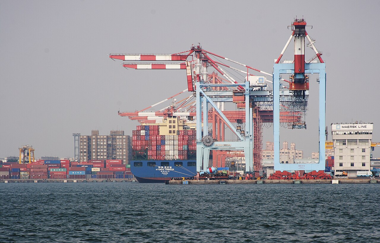
The Aomi Container Terminal in the Port of Tokyo has 1570 meters in five berths. The Tokyo Metropolitan Government operates three of the berths, and the Tokyo Port Terminal Corporation operates two of the berths. The berths are equipped with 12 container cranes. The Port of Tokyo's Aomi Container Terminal can accommodate large container vessels up to 50 thousand DWT. The Aomi Cargo Distribution Center occupies two buildings behind the wharf and has capacity to handle, store, and convey cargoes.

The Port of Tokyo's Shinagawa Container Terminal is a public terminal managed by the Tokyo Metropolitan Government. Opened in 1967, it is the oldest container terminal in Japan. Today, it serves container routes to China, Korea, Southeast Asia, and coastal routes.

Saturday, December 17, 2011

Port Of Mumbai, India

The Port of Mumbai (formerly Bombay) is a deep natural harbor on India's northwest coast just six nautical miles west of the Jawaharlal Nehru Port at Nhava Sheva and some 432 nautical miles south-southeast of the Port of Kandla. One of the world's largest municipalities, with its suburbs of Navi Mumbai and Thane, the Port of Mumbai's metropolitan area of some 19 million people is the fifth most populous in the world.

The Port of Mumbai is the capital of the Maharashtra state and India's commercial and entertainment center. One of the most important commercial centers in the world, the Port of Mumbai is home to India's major financial institutions with many headquarters for Indian corporations and branch headquarters for lots of multi-national corporations. Known as Bollywood, the Port of Mumbai is the center for the Hindi entertainment industry. With its big-city excitement and high standard of living, the Port of Mumbai attracts people from all over the country, making it a mixing pot for many cultures. The Port of Mumbai is also the gateway for more than half of India's sea-going passengers and an important cargo-handling seaport.

The Mumbai Port Trust administers the Port of Mumbai through a board of Trustees representing the port's major stakeholder groups, including shippers, labor, and government. While the Board plays an administrative and management role, daily operations are led by department heads that are supervised by the Board's chairman. The Mumbai Port Trust strives to provide cost-effective customer-oriented services by continuously improving port systems and processes, assuring safety, and protecting the environment.

In the 2007-2008 shipping year, the Port of Mumbai handled a total of over 57 million tons of cargo, including 32.4 million tons of imports and 24.7 million tons of exports. The Port of Mumbai handled 1.4 million tons of containerized cargo in 117.6 thousand TEUs.

Imported cargoes through the Port of Mumbai were dominated by crude oil (12.7 million tons), stream cargo (6.4 million tons), miscellaneous cargoes (4.2 million tons), POL products (3.4 million tons), and iron and steel (2.8 million tons). Other imports included bulk chemicals, containers, edible oils, rock phosphate, fertilizers, and sulfur. Containerized imports of 627.3 thousand tons were in 71.7 thousand TEUs.

Port of Mumbai export cargoes were dominated by crude oil (13.7 million tons), POL products (7.2 million tons), iron and steel (1.3 million tons), containers (886 thousand tons), miscellaneous cargoes (647 thousand tons), sugar (587 thousand tons), and bulk chemicals (102 thousand tons). Other exports included molasses, oil cakes, edible oil, and food grains. Containerized exports of 763.4 thousand tons were in 45.8 thousand TEUs.
With a 400 square kilometer natural deep-water harbor, the Port of Mumbai is protected by the mainland to the east and the island of Mumbai to the west. The Port of Mumbai has a total area of 46.3 hectares, total quay length of 7.8 thousand meters, and 63 anchorage points. Pilotage is necessary for vessels of 100 tons and above entering and leaving the harbor. The Port of Mumbai includes three enclosed wet docks: Prince's Dock, Victoria Dock, and Indira Dock. Prince's and Victoria are both semi-tidal docks.

Commissioned in 1880, the Port of Mumbai's Prince's Dock is the oldest of the three. It contains eight berths with alongside depth of 6.4 meters. The Victoria Dock, commissioned in 1888, has 14 berths with alongside depth of 6.7 meters. The youngest, Indira Dock, was commissioned in 1914. It has a 228.6-meter-long, 30.5-meter-wide entrance lock and a total of 26 berths (21 inside the basin and 5 on the harbor wall). The berths inside the harbor have alongside depth of about 9 meters, and the at the harbor wall have alongside depth of about 7 meters.

The Prince's Dock's eight berths total 1220 meters long and have alongside depths from 6.1 to 6.4 meters. Two of those Port of Mumbai berths are 212 meters long, four are 140 meters long, two are 138 meters long, and one is 100 meters long.

The Port of Mumbai's Victoria Dock has 14 multi-purpose berths a total of 1732 meters long, all with alongside depth of 6.7 meters. Eight of those berths are each 122 meters long. Three are 152 meters long, and three are 100 meters long. A 15th berth at Victoria Dock is reserved for Mumbai Port Trust tugs and launches.
Four Port of Mumbai jetties, handling petroleum, oil, and lubricant (POL) tankers, are located at Jawahar Dweep. Two jetties can accommodate tankers up to 70 thousand DWT, and the newest jetty can handle tankers up to 125 thousand DWT with maximum draft of 12.2 meters. An offshore berth at the Port of Mumbai's Pir Pau handles liquid chemicals and some POL cargoes, and it can accommodate tankers of up to 47 thousand DWT with a maximum draft of 11.1 meters.

Tuesday, December 13, 2011

Port Of Laem Chabang, Thailand

The Port of Laem Chabang lies on the southeastern shores of the Gulf of Thailand about 50 nautical miles south-southeast of Bangkok and about 32 nautical miles north of Thailand's Sattahip Commercial Port. In 2006, almost 62 thousand people lived in the Port of Laem Chabang.


The Port of Laem Chabang is the third largest port in Thailand, and it was created to take some of the burgeoning commercial traffic that was overloading the Port of Bangkok. It is also the major cruise port for Bangkok. In 2007, the American Association of Port Authorities (APPA) ranked the Port of Laem Chabang as the 21st busiest container port in the world. The local economy is based on shipping, retail, and tourism. The Port of Laem Chabang is home to the world-class golf course designed by Jack Nicklaus at the Laem Chabang International Country Club and an ExxonMobil refinery.


Since the Port of Laem Chabang began operating in 1991, it has become the biggest port in the country and one of the busiest in the world. Much of Thailand's international trade and tourism passes through the Port of Laem Chabang. In 2007, the government approved construction of railways to link the Port of Laem Chabang to inland cities of Lat Krabang and Korat.


The Port Authority of Thailand governs the activities and operations of the Port of Laem Chabang. The Port of Laem Chabang is Thailand's major deep-sea port handling international freight. The Port of Laem Chabang can accommodate extra-large super post Panamax vessels. The Port Authority of Thailand (PAT) administers both the Port of Bangkok and the Port of Laem Chabang. With the growth in ocean-borne trade, the PAT has grown in both responsibility and size. Today, it is responsible for all port infrastructure supporting Thailand's increasing exports.


The Port of Laem Chabang lies some 100 kilometers southeast of Bangkok at the heart of the thriving Cholburi Province economy which also includes the fishing port of Si Rachi and the beach resorts of Pattaya. The Port of Laem Chabang covers about one thousand hectares and serves large ocean-going container ships and bulk carriers carrying cargoes to be transshipped to Bangkok and other parts of Thailand.


The long-term plan for the Port of Laem Chabang envisions it as a link with other countries in Indochina through water, road, and air transportation networks. The Port of Laem Chabang Industrial Estate Export Processing Zone, located near the port, covers 480 hectares and over 50 industrial operations that import many materials and export products through the Port of Laem Chabang. Furthermore, the Port of Laem Chabang Shipyard is being developed to build and service ships according to the highest international standards.


The Port of Laem Chabang has modern facilities and equipment to handle large volumes of cargo with efficiency and timeliness. The Port of Laem Chabang has large mobile cranes, top loaders, shifters, rail-mounted gantry cranes, and container shifters to handle any type of cargo. The Port of Laem Chabang leases out the operation of its container and bulk terminals to private operators. Thailand is the world's largest exporter of tapioca products, and the Port of Laem Chabang's agribulk terminals handle most of those exports.


In 2008, over eight thousand vessels called at the Port of Laem Chabang. The vast majority of these vessels were cargo ships (5,975). The total also included 267 general cargo vessels, 674 roll-on/roll-off vessels, and 26 passenger vessels. In 2008, the Port of Laem Chabang handled a total of more than 5.2 million TEUs of containerized cargo carrying over 52 million tons of cargo and over 2.7 million tons of general merchandise. General merchandise included over 2.2 million tons of exports, and containerized cargoes included more than 2.6 million TEUs of exports and almost 2.6 million TUEs of imports. The Port of Laem Chabang handled over 861.8 thousand cars, including more than 799 thousand outgoing vehicles. In the same year, more than 55 thousand passengers moved through the Port of Laem Chabang.

Monday, December 12, 2011

Port Of Bremen/Bremerhaven, Germany

The Port of Bremerhaven lies on both banks of the Geest River as it enters the eastern Weser estuary about 70 kilometers from the North Sea in northern Germany. The Port of Bremerhaven is about 20 nautical miles east of the Port of Wilhelmshaven on the western banks of the estuary and about 276 kilometers northeast of Amsterdam. In 2003, over 118 thousand people lived in the Port of Bremerhaven.

The Port of Bremerhaven is the seaport for the city-state of Bremen. While is a new city by European standards, it has long been an important port for trade, and it one of Germany's principal seaports. The Port of Bremerhaven is the fourth biggest container port in Europe and the world's sixteenth largest container port. More cars move through the Port of Bremerhaven than any other European city but Rotterdam.

The Port of Bremen is the capital of the state of Bremen, an enclave in Lower Saxony in northwest Germany. On the banks of the Weser River about 70 kilometers inland from the North Sea, it is one of German’s most important ports and industrial centers. The state of Bremen’s official name is Freie Hansestadt Bremen, acknowledging its historic membership in the Hanseatic League. In 2006, almost 544 thousand people lived in the Port of Bremen, but over two million people lived in the Bremen-Oldenburg metropolitan area.

Bremenports (German) has managed the Bremen/Bremerhaven Port Group on behalf of the City of Bremen since 2002. Bremenports is responsible for operation and maintenance of Port of Bremerhaven infrastructure that includes 33.9 kilometers of quays, 186 kilometers of port rail tracks, 56 bridges, 5 locks, and over 9 kilometers of docks. Bremenports also manages port lands, including customer services, previously managed by the Bremen Port Authority. Finally, Bremenports markets the Port of Bremerhaven under the brand "Bremenports Bremen/Bremerhaven."

Together, the Ports of Bremen and Bremerhaven offer comprehensive cargo-handling and logistics services hard to match elsewhere in Europe. Most of the port facilities serving the City of Bremen are located in the Port of Bremerhaven. The Port of Bremerhaven offers the world's biggest closed turnover area for containers.

In 2008, the Port of Bremerhaven handled a total of 74.5 million tons of cargo, including almost 65 million tons of general cargo and 9.5 million tons of bulk cargo. Of this total, 38.8 million tons were imports, and 35.7 million tons were exports. The Port of Bremerhaven handled almost 54.7 million tons of containerized cargo in more than 5.4 million TEUs. The Port of Bremerhaven also handled almost 2.1 million vehicles in 2008, including over 1.2 million exports and almost 800.8 thousand imports.

The Port of Bremerhaven specializes in handling containers and automobiles. The Port of Bremerhaven has capacity to handle almost 5.5 million TEUs and 55 million tons of containerized cargo per year. The Port of Bremerhaven boasts the fourth-largest container terminal in Europe and a five-kilometer long container quay with 14 berths that can accommodate mega-container vessels. With an operating area of about 90 hectares, the new container terminal 4 has 3.2 thousand meters of quay with capacity to handle over seven million TEUs.

The Port of Bremerhaven has capacity annual for over two million units of automobiles, and it offers storage space for 120 thousand cars, including covered area for 45 thousand cars. The Port of Bremerhaven includes 15 berths dedicated to car carriers.

The Port of Bremerhaven invested over 20 million Euros to convert the 40-year-old Columbus Railway Station into the new modern Columbus Cruise Center Bremerhaven. The new terminal treats arriving passengers to shops, restaurants, and great views of the ships traveling the Outer Weser River. In 2002, only 53 cruise ships carrying about 50 thousand passengers called at the Port of Bremerhaven. In 2008, the Port of Bremerhaven served more than 127 thousand passenger trips and 91 cruise vessels.

Port Of Xiamen, China

The Port of Xiamen is located in southeast China’s Fujian Province on the coast of Xiamen Island on an inlet of the Taiwan Straight. The Port of Xiamen has an excellent natural harbor protected by offshore islands. Known by many as the “Garden on the Sea,” the area has a warm humid subtropical climate. Recently, the Port of Xiamen was recognized as the People’s Republic of China’s second most livable city. In 2007, the metropolitan area was home to more than 2.5 million people.

Many overseas Chinese call Xiamen their ancestral home, and the Port of Xiamen is one of the country’s first Special Economic Zones. Tourists will find many attractions in Xiamen, a city in a region of beautiful scenery and tree-lined beaches. It houses a national treasure from the Tang Dynasty, the Buddhist Nanputuo Temple. Since the 1980s, the Port of Xiamen has been open to foreign investment, which has created jobs, industries, and export opportunities for many companies. The city’s major economic activities include ship-building, tanning, textiles, chemical industries, manufacturing of machine tools, telecommunications, financial services, and fishing.


Europeans first entered the port in 1541. The local Hokkien Amoy dialect shaped how many Chinese was translated (kio-chap is ketchup, pe’h-ho is Pekoe, Ji’t-pun is Japan). The 1842 Treaty of Nanjing ending the First Opium War made the Port of Xiamen one of five treat ports open to British trade, bringing Protestant missions to China among other things.


The Port of Xiamen is one of China’s top ten ports. Its natural deep-water, ice-free harbor never silts up and is open year-round. It is located on Xiamen Island at the mouth of the Jiulong River just over 200 kilometers northwest of the island of Taiwan. The Port of Xiamen covers 64.5 kilometers of coastline with waters more than 12 meters deep.

The Port of Xiamen contains 81 berths, including 16 deep-water berths. Six of those are dedicated to containerized cargo. The Inner port can accommodate 100-thousand tone vessels, and 50-thousand ton vessels can dock there.

While the Port of Xiamen has traded with Hong Kong, Korea, Japan, and Singapore for many years, it has recently opened trade routes to the Americas, the Mediterranean, and Europe. In 2000, the Port of Xiamen handled over 19.6 million tons of cargo and over 108 thousand TEUs of containerized cargo. By 2010, the Port of Xiamen hopes to have capacity to handle 120 million tons of cargo and 10 million TEUs of containerized cargo.

The Port of Xiamen has abundant direct connections to inland China through rail and highway with direct connections to port facilities.

Saturday, December 10, 2011

Port Of Long Beach, USA

The Port of Long Beach is located in Los Angeles County, California, and it is the second largest city in the LA metropolitan area about nine kilometers east-northeast of the Port of Los Angeles and about 90 kilometers northwest of the Port of San Diego. Lying on the shores of San Pedro Bay, the Port of Long Beach is connected to Los Angeles harbor by the Los Cerritos Channel, and it is one of the world's busiest ports. In 2006, over 472 thousand people lived in the Port of Long Beach, and almost 13 million people lived in the Los Angeles-Long Beach-Santa Ana metropolitan area.

The Port of Long Beach economy is diverse, with manufacturing, services, oil refining, food processing, and marine research as its dominant sectors. The Port of Long Beach's largest employers include Boeing, Gulfstream Aerospace, and Verizon. There are also several major hospitals in the Port of Long Beach that employ thousands of people. Government and educational institutions are also important employers in the Port of Long Beach. The Monster Garage cable TV show is filmed in the Port of Long Beach, and Jesse James' West Coast Choppers is located there.


The Los Angeles Dock and Terminal Company declared bankruptcy in 1916 and turned over their projects to the City of Long Beach, which then completed dredging the channels and turning basin. In 1917, the Port of Long Beach Board of Harbor Commissioners was created to supervise harbor operations.

By 1926, the Port of Long Beach won deep water port status. It welcomed more than 800 vessels and handled over a million tons of cargo. In 1928, the Port of Long Beach began to build more piers, wharves, and port facilities. The Municipal Wharf, Pier One, was built, and Piers A and B were started in the outer harbor.

The Federal River and Harbor Act authorized the building of a 5.6-kilometer extension to the Port of Long Beach's San Pedro Bay breakwater in 1930. In 1931, the City Charter was amended to create a Board of Harbor Commissioners, a Harbor District, and a Harbor Department. In 1936, oil was discovered in the Port of Long Beach harbor, and the first oil well brought new oil revenues to the city and port by 1938.

During the first half of the 20th Century, the Port of Long Beach was home to a large Japanese-American community. The people worked on Terminal Island in the fish canneries and on small truck farms. In 1942, however, the Japanese-Americans and Japanese residents of the Port of Long Beach were moved to internment camps during World War II. Few returned to the Port of Long Beach after the end of the war.

In 1943, more than a hundred oil wells in the Port of Long Beach harbor produced 17 thousand barrels a day, bringing $10 million in oil revenues to the city and Port of Long Beach each year. However, by 1945, the consequences of oil extraction had become a major concern for the Port of Long Beach.

In 1943, the US Naval Dry Docks were established at the Port of Long Beach to maintain and repair tankers, cargo ships, destroyers, cruisers, and troop transports during World War II. In 1945, the dry docks employed more than 16 thousand civilians. Also in 1945, it became the Long Beach Naval Shipyard (NSY) in 1948. Over the years, the Port of Long Beach NSY boasted several major accomplishments including projects supporting programs like SEALAB, POSEIDON, and POLARIS. The Port of Long Beach NSY closed in 1997.

In 1946, the Port of Long Beach became "America's most modern port" when the first clear-span transit sheds were completed at Pier F. Pierpoint Landing opened on Pier F in 1948 and quickly became the world's biggest sport-fishing operation, receiving more than two million fishers per year.

By 1957, shifting of the surface downwards (subsidence) due to oil and gas exploitation caused over four thousand hectares in the north harbor to sink by as much as seven meters. Operation Big Squirt began in 1960 and stopped the subsidence problem.

In 1967, the Port of Long Beach bought the world-famous British trans-Atlantic liner, the Queen Mary, and moored in the harbor as a maritime museum, hotel, and conference center adjoining the Long Beach Convention and Entertainment center.

In 1973, the Port of Long Beach was awarded the Environmental "E" Award by the American Association of Port Authorities for its efforts to protect and improve the environment. The Port of Long Beach was the first harbor in the Western Hemisphere to receive this award. In 1974, the United States Department of Commerce recognized the Port of Long Beach with the E-Star Award for its efforts to encourage and facilitate exports.
From the early 1980s until the early 1990s, the Port of Long Beach displayed Howard Hughes' historic Spruce Goose airplane before it was moved to Portland, Oregon. The huge building that held the plane then became a movie studio.

In 1994, the Port of Long Beach signed an operating agreement with the Port of Los Angeles and the Santa Fe, Pacific and Union Pacific railroads to operate a 32-kilometer train and truck expressway from the ports to the transcontinental rail yards in Los Angeles.

In 1998, the non-profit Aquarium of the Pacific opened in the downtown Port of Long Beach. Over 13 million people have visited the aquarium since then, and it has been ranked the number two family destination in Los Angeles, second to Disneyland, by the Zagat U.S. Family Travel Guide. The Aquarium was the first museum, zoo, or aquarium to become a Climate Action Leader for voluntarily addressing green house gas emissions.

Port Of Tanjung Pelepas, Malaysia

The Port of Tanjung Pelepas has recorded tremendous growth from its beginnings in 1999 to becoming South East Asia's fastest growing container terminal which in 2003 handled approximately 3.5 million TEUs.

PTP also offers over 1000 acres of commercial and industrial free zone. The excellent connectivity via road, rail, air or sea that PTP offers has been a major factor that has attracted companies like BMW, Schenker Logistics, Maersk Logistics and Kenwood Logistics to set up operations here.

PTP is now preparing to meet the demands of the future with the development of Phase II which comprises an additional 2.8 Km of linear wharf. The first 2 berths which are under construction will be completed by mid 2004. Upon completion of the 2 berths, PTP will have an annual capacity of 6 million TEUs.

Tanjung Pelepas Port lies at the mouth of the Pulai River on the southwestern shores of Peninsular Malaysia near the major shipping lanes in the Strait of Malacca. Johor Port Authority is responsible for managing the Tanjung Pelepas Port.


Tanjung Pelepas Port contains six berths, totaling 2160 meters with alongside depth of at least 15 meters, that can accommodate vessels to 115 thousand DWT. Tanjung Pelepas Port’s berths are positioned in naturally deep waters, and there is a wide approach channel. With a turning basin of 600 meters, the largest container vessels can move easily in and out of the port.


Just 45 minutes from the world’s busiest shipping routes and about 11 kilometers from the Port of Singapore and 40 kilometers from Johor Port, Tanjung Pelepas Port is well-positioned to perform both regional and worldwide transshipment and cargo distribution services.

Tanjung Pelepas Port is a world-class port that maintains state-of-the-art facilities and infrastructure. The container yard was designed to handle eight million TEUs of containerized cargo per year. Covering an area over 3.1 million square kilometers, Tanjung Pelepas Port contains ground slots for 29.8 thousand TEUs, four thousand reefer points, and storage capacity for 200 thousand TEUs.

Thursday, December 8, 2011

Port Of Kaohsiung, Taiwan

The Port of Kaohsiung encompasses five container terminals. All are at your service to handle a comprehensive range of logistics services promptly and accurately. With an annual handling capacity of 10 million TEU, the Port of Kaohsiung handles shipments quickly and effectively with state-of-the-art facilities, equipment and supporting infrastructure and professional, well-trained staff.

The Port of Kaohsiung lies on the southwestern shores of the island of Taiwan about 180 kilometers south of the Port of Taichung. Taiwan's principal port and the sixth largest container port in the world, Kaohsiung City is an important industrial center as well, with the 2.2 thousand hectare Linhai Industrial Park located on the waterfront near the Port of Kaohsiung. The industrial park contains a shipyard, a petrochemical complex, a steel mill, and many other industries. In 2008, the municipality of Kaohsiung City was home to over 1.5 million people, and more than 2.7 million lived in the metropolitan area.

Kaohsiung City is also home to many manufacturing plants and an oil refinery. Manufacturers produce aluminum, cement, refined sugar, salt, brick and tile, fertilizer, and paper. The Port of Kaohsiung is an export center for agricultural products produced across southern Taiwan, and it is also an important fishing port. The city also supports a major canning industry that processes both fish and fruit.

The Kaohsiung Harbor Bureau is the port authority for the Port of Kaohsiung. In late 2008, President Ma met with city and port officials and shipping company heads to discuss the future of the Port of Kaohsiung. Several proposals resulted from the meeting that included:

  • expanding internationalization and liberalization of the Port of Kaohsiung
  • restricting use of the commercial wharves to maintain the port's integrity
  • expansion of the container yards and improvements to connections between container terminals

Port Of Tianjin, China

The Port of Tianjin lies at the head of the Hai River about 26 nautical miles inland from the Bohai Gulf off the Yellow Sea on China's east coast. About 160 kilometers southeast of Beijing, the Port of Tianjin is 225 nautical miles west across the Bohai Gulf from the Port of Dalian. It is also connected to the Yangtze River by the Grand Canal. As the commercial gateway to Beijing and a maritime center, the Port of Tianjin is a ethnically diverse and cosmopolitan city. In 2005, the Tianjin municipality was estimated to hold over 10.2 million people, making it the sixth largest city in the People's Republic of China.

The Port of Tianjin's manufacturing sector is the biggest and fastest-growing part of the city's economy. The Tianjin municipality is about 40% farmland, and rice, wheat, and maize are its most important crops. Fishing is also important to the local economy. The Port of Tianjin also has an important industrial sector dominated by petrochemical industries, car manufacturers, textiles, metalworking, and mechanical industries. The municipality has reserves of about one billion tons of petroleum. Salt and geothermal energy are also important natural resources, and it had the countries first discovered deposits of manganese and boron.

The Port of Tianjin Authority operates the port. The Tianjin Port (Group) Company, Limited (Chinese) is the main operator in the Port of Tianjin, and it employees 20 thousand people. The Port of Tianjin is China's biggest artificial harbor and an important port for foreign trade. The access channel for the Port of Tianjin is 44 kilometers long and can accommodate ships up to 250-thousand tons (at low tide) with maximum draft of 19.5 meters. The Port of Tianjin's shoreline stretches for 21.5 kilometers.

The Port of Tianjin serves a vast hinterland that includes Beijing as well as the central and western areas of 14 provinces, municipalities, and autonomous regions that cover almost five million square kilometers and over half of the country. The Port of Tianjin has trade relationships with over 600 ports in 180 countries and regions around the world.

The Port of Tianjin contains more than 140 berths and the capacity to handle more than 289 million tons of cargo and over 9 million TEUs of containerized cargo per year.

One of the major cargoes handled and stored in the Port of Tianjin is coal. Seven specialized berths in the Port of Tianjin are devoted to handling coal exports and imports. The Port of Tianjin's Coal Terminal has capacity for 89 million tons of coal throughputs per year.

The Port of Tianjin's Container Yard covers over 350 hectares and can store 8.3 million tons of containerized cargo at one time. The Port of Tianjin Coal Terminal Company has a yard of 300 thousand square meters with capacity to store more than 1.7 million tons. The Port of Tianjin contains a total of 280 hectares of yards for bulk cargoes, and it can store up to 5.1 million tons of bulk at one time. The Port of Tianjin Shenhua Terminal Company offers 430 thousand square meters of yards with capacity for one-time storage of over 1.4 million tons of cargo.

Tuesday, December 6, 2011

Port Of Qingdao, China

The Port of Qingdao (also spelled Tsingtao, means "pearl of the Yellow Sea") rests at the entrance to Jiaozhou Bay on the south coast of Shadong Peninsula overlooking the Yellow Sea in eastern China. The Port of Qingdao is located some 94 nautical miles northeast of the Port of Liayungang and about 300 nautical miles west-southwest of the Port of Incheon in South Korea. Offering one of northern China's best natural harbors, the bay is open year-round for large vessels. The Port of Qingdao is an important cultural center with several important universities. It is also a major center for marine sciences and technology. In 2007, over 2.8 million people lived in the urban area surrounding the Port of Qingdao.

In 1984, the government of the People's Republic of China named part of Qingdao a Special Economic and Technology Development Zone, supporting the city's growth with secondary and tertiary industries. As one of China's fourteen open cities, the Port of Qingdao supports a local economy that thrives on international trade and foreign investments. Japan and South Korea have made significant investments in the city, and about 80 thousand South Korean citizens live there. The hinterlands of the Port of Qingdao contain more than 20 hectares of arable land, so agriculture is an important part of the regional economy. Marine resources like fish, shrimp, and other ocean products are also important to the economy. Minerals mines and paper mills also contribute. The Port of Qingdao is home to three industrial zones: Qingdao Economic and Technological Development Area, Qingdao Free Trade Zone, and Qingdao High-tech Industrial Zone.

Governed by the Qingdao Port Authority, the Port of Qingdao has trade relations with more than 450 ports in over 130 countries around the world. With a natural deep-water silt-free harbor, the Port of Qingdao is an important center for international trade and ocean-going transportation.

The Port of Qingdao contains three major areas: the Old Port, Huangdao Oil Port, and Qianwan New Port. The Port of Qingdao is equipped to handle a wide range of general, bulk, and project cargoes. The major cargoes handled by the Port of Qingdao include containers, iron ore, coal, crude oil, and grain. Other cargoes include aluminum, fertilizer, sodium carbonate, cement, rubber, sodium carbonate, wood pulp, cotton, lumber, and ironware.
In 2007, the Port of Qingdao handled a record 265 million tons of cargo, including 190 million tons of foreign cargo and 9.5 million TEUs of containerized cargo, making it the second busiest port in mainland China. In that year, the Port of Qingdao opened a new liquid chemical wharf and a new container terminal and launched the largest cold store in China. In the first half of 2008, the Port of Qingdao had already handled over 150 million tons of cargo.
The Qingdao-Jinan Expressway and the Jiaozhou-Jinan Railway both start in the Port of Qingdao, offering fast and convenient transport of goods into the interior. The Port of Qingdao has 70 working berths, including 24 deep-water berths that can accommodate vessels over 10 thousand DWT. The Port of Qingdao is also a busy fishing port.

Port Of Los Angeles, USA

The Port of Los Angeles is located in San Pedro Bay, 20 miles south of downtown Los Angeles. This thriving seaport not only sustains its competitive edge with record-setting cargo operations, but is also known for its groundbreaking environmental initiatives, progressive security measures, diverse recreational and educational facilities, and an emerging LA Waterfront.


The Port of Los Angeles encompasses 7,500 acres of land and water along 43 miles of waterfront. It features 25 passenger and cargo terminals, including automobile, breakbulk, container, dry and liquid bulk, and warehouse facilities that handle billions of dollars worth of cargo each year.
When measured by container throughput, the Port has consecutively ranked as the number one port in the nation for the last decade.


Amidst the backdrop of international trade and shipping, the Port of Los Angeles also boasts the bustling World Cruise Center, quaint Ports O’ Call Village, welcoming Vincent Thomas Bridge, signature Fanfare Fountains and Water Features, historic Angels Gate Lighthouse, vintage Waterfront Red Car Line, and new green space at 22nd Street Park.


With an exceptional credit record, the Port maintains an Aa2 bond rating, the highest assigned to any seaport in the United States, operating without the benefit of taxpayer support. The Port also wields tremendous economic impact, generating employment for more than 3.3 million Americans nationwide. In California alone, nearly 1 million jobs are related to trade though the Port of Los Angeles.
Complementing its busy terminal operations with green alternatives, the Port of Los Angeles remains committed to managing resources and conducting Port developments and operations in both an environmentally and fiscally responsible manner. The Port of Los Angeles is the United States' second biggest city and one of its busiest seaports. Located in Southern California on between the Pacific Ocean and the San Gabriel Mountains, it is about nine kilometers west-southwest of the Port of San Diego and almost 390 nautical miles south-southeast of the Port of San Francisco. A city with many distinct neighborhoods, it is located near the famous San Andreas Fault, and earthquakes occur often. It is the seat of Los Angeles County, which is home to almost one hundred other cities. In 2005, over 3.8 million people lived in the Port of Los Angeles, and the Los Angeles-Long Beach-Santa Ana metropolitan area was home to more than 12.9 million.


The local economy of the Port of Los Angeles is gigantic, diverse, and always changing. Growing on agriculture in the early years, today the Port of Los Angeles is a center for finance and business, high-technology, fashion industries, and, of course, movies. In the late 20th Century, the Port of Los Angeles had an economic downturn that began to recover after the beginning of the 21st Century, with high-technology leading the way. Since the recent global recession, many manufacturing plants have closed, and high-paying jobs have decreased. Low-paying jobs have grown, and immigrant labor has become more important to employers in the Port of Los Angeles. There are even some sweat shops in the Port of Los Angeles area.

Monday, December 5, 2011

Port Of Hamburg, Germany

The Port of Hamburg (German mostly: Hamburger Hafen) is a port in Hamburg, Germany, on the river Elbe. The harbour is located 110 kilometres from the mouth of the Elbe into the North Sea. It is named Germany's "Gateway to the World" and is the largest port in Germany. It is the second-busiest port in Europe (after the port of Rotterdam), in terms of TEU throughput, and 11th-largest worldwide. 9.74 million containers were handled in Hamburg in 2008.
The harbour covers an area of 73.99 km² (64.80 km² usable), of which 43.31 km² (34.12 km²) are land areas. The location is naturally advantaged by a branching Elbe, creating an ideal place for a port complex with warehousing and transshipment facilities. The extensive free port also enables toll-free shipping.

The history of the port is almost as old as the history of Hamburg herself. Founded on May 7, 1189 by Frederick I for its strategic location, it has been Central Europe's main port for centuries and enabled Hamburg to develop early into a leading city of trade and a rich and proud bourgeoisie.
During the age of the Hanseatic League in the 13th to 17th century, Hamburg was considered second only to port and city of Lübeck, in terms of its position as a central trading node for sea-borne trade.

Port Of Antwerp, Belgium

Antwerp is Europe’s second largest port and the fourth largest in the world. In 2005 the Port of Antwerp handled over 160 million tons of maritime goods. Every year, 15,000 ocean-going vessels and over 64,000 inland crafts call at the port. More than 140,000 people make a living directly or indirectly from the Port of Antwerp.

The Port of Antwerp is an indispensable link in the European Union import/export chain and a hub for a great many trading activities worldwide. Container traffic is experiencing explosive growth of ten to fifteen per cent a year. Containers account for more than forty per cent of maritime traffic at the Port of Antwerp.
Antwerp Port Authority is accommodated at the Havenhuis, which also houses a library on port economics and transport. The library is open workdays between 9 am and 4 pm by appointment.


The Port of Antwerp is the gateway to Europe, handling 178.2 million tonnes of freight in 2010. Antwerp is the second largest port in Europe for international shipping freight and the tenth largest in the world.
Its central position in North-West Europe and its excellent connections with the most important centres of industry and consumption in Europe have led to Antwerp becoming a very important link in the chain of international trade.
But the port is much more than just a loading and unloading point: here, goods are also stored, repacked, distributed and made ready for transport to their final destinations.
Thanks to its enormous storage capacity the port acts as the “supermarket of Europe” where all types of products obtain the specialised handling and storage that they require.
Antwerp is also the ideal port for the future, as it is the only port where millions of tonnes of freight can be carried so far inland. Freight can be brought 80 km inland to Antwerp by the most environment-friendly of all transport modes, avoiding many truckloads being carried over the same distance. From a European perspective Antwerp is the best choice not only from an economic but also from an ecological point of view.
Strong in this conviction, the port of Antwerp has set itself the firm ambition of expanding its annual freight volume to 300 million tonnes.


Sunday, December 4, 2011

Port Of Ningbo, China

The Port of Ningbo lies on the coastal plain on the Yong River about 25 kilometers upstream from the Hangzhou Bay, about 154 kilometers south of the Port of Shanghai. It has long been a port, and it has an outport on the western estuary bank that was a fishing port. It is south of the Bay and faces the East China Sea, separated from Zhoushan by a narrow waterbody.
Once famous for producing traditional Chinese furniture, the Port of Ningbo dates as far back as the Hemudu culture of 4800 BC. In 1986, Chine designated the Port of Ningbo one of its national historic and cultural cities. It contains the oldest library building in China with a collection of rare books dating to the 11th Century. In 2007, the metropolitan area was home to over 1.9 million people.


The Port of Ningbo became an independent prefecture under the Ming Dynasty in 738. Under the Southern Song Dynasty, it was promoted to a superior prefecture in 1195 called Quangyuan. In 1381, it became the Ningbo superior prefecture, a status it maintained until 1912 when it was demoted to county status with the name of Yin Xian. In 1949, it was separated from the county to form the modern city of Ningbo.
The Port of Ningbo was a convenient port for Korean mariners in the late 5th Century, making it an important port for eastern China. Even when official relations with Korea collapsed in 838 AD, large-scale private trading continued.
The Port of Ningbo was a center for coastal trade in the early 11th Century, and its position became more pronounced in 1127 when the South Song capital was established at Hangzhou and overseas trade began to flow through Ningbo. The Port of Ningbo grew rapidly and became rich from the 10th to 13th Centuries.

Port Of Klang, Malaysia

The Port of Klang is located in the District of Klang, it was the 13th busiest transshipment port (2004) and the 16th busiest container port (2007) in the world. It was also the 26th busiest port in by total cargo tonnage handled in 2005.
It is the main gateway by sea into Malaysia. Colonially known as Port Swettenham, it is also the location of the largest and busiest port in the country. As such, its economic progress has been greatly influenced by the port activities in its area. It is located about 6 kilometres (3.7 mi) southwest of the town of Klang, and 38 kilometres (24 mi) southwest of Kuala Lumpur. Both Klang and Port Swettenham were already known as notoriously malaria prone localities with the port itself located on a mangrove swamp. Within two months of its opening, the port was closed due to an outbreak of malaria. Just a few years before, Britain's Sir Ronald Ross proved in 1897 that malaria is transmitted by mosquitoes. Port Swettenham was the first colonial area to benefit from the discovery. Swamps were filled in, jungle cleared, and surface water diverted to destroy mosquito breeding grounds and combat further disruption to port operations. The threat of malaria was removed completely by the end of the exercise. Trade grew rapidly and two new berths were added by 1914 along with other port facilities. The Selangor Polo Club was founded in Port Swettenham in 1902 but it moved to Kuala Lumpur in 1911.


Klang was formerly the terminus of the government railway and the port of the State. In 1880, the state capital of Selangor was moved from Klang to the more strategically advantageous Kuala Lumpur. Rapid development at the new administrative centre in the late 1800s attracted businessmen and job seekers alike from Klang. At this time the only methods of transport between Klang and Kuala Lumpur were by horse or buffalo drawn wagons, or boat ride along the Klang River to Damansara. Due to this Frank Swettenham stated to Selangor's British Resident at the time, William Bloomfield Douglas, that the journey to Kuala Lumpur was “rather long and boring”. He continued to suggest a train line be built as an alternative route.
In September 1882, Sir Frank Athelstane Swettenham was appointed Selangor’s new Resident. Swettenham initiated a rail link between Klang and Kuala Lumpur to overcome the transport problems particularly of the tin mining interests, who needed to convey the ore to Klang's port, Pelabuhan Batu. Nineteen and a half miles of rail track from Kuala Lumpur to Bukit Kudu was opened in September 1886, and extended 3 miles to Klang in 1890.
The river navigation, however, was difficult as only ships drawing less than 3.9 metres (13 ft) of water could come up the jetty, and thus a new port was selected near the mouth of the river as the anchorage was good. Developed by the Malayan Railway and officially opened 15 years later in 15 September 1901 by Swettenham himself, the new port was named Port Swettenham.


Port Of Dubai, United Arab Emirates

Port of Dubai is a man made, commercial port in Dubai, United Arab Emirates. At the time the port only had two gantry cranes and a capacity of less than 100,000 TEUs. In 1978, the port was expanded to include 35 berths (five of which were able to be used by the largest container ships at the time). Today, the port (which has a depth of 13 metres (43 ft)) has 9 gantry cranes and a capacity of 1,500,000 TEUs.
Today, Port Rashid provides berths for general cargo, RoRo and passenger vessels. In the early 1980s, Port Rashid was supplemented by Port of Jebel Ali, which is further from the commercial centre of Dubai near the Abu Dhabi border.
Adjacent to the port are Dubai Drydocks and Dubai Maritime City. Both of these facilities were built due to Port Rashid's proximity. But, in January 2008, it was announced that the port would be redeveloped. All cargo operations will move to Jebel Ali Port by the end of March 2008. Also, part of the port will be reclaimed by Nakheel to create "a vibrant mixed use urban waterfront" that will house 200,000 residents. DP World operates more than 60 terminals across six continents(1), with container handling generating around 80% of its revenue.  In addition, the company currently has 10 new developments and major expansions underway in10 countries. 
DP World aims to enhance customers’ supply chain efficiency by effectively managing container, bulk and other terminal cargo.  Its dedicated, experienced and professional team of nearly 30,000 people serves customers in some of the most dynamic economies in the world. 
The company constantly invests in terminal infrastructure, facilities and people, working closely with customers and business partners to provide quality services today and tomorrow, when and where customers need them.
In taking this customer-centric approach, DP World is building on the established relationships and superior level of service demonstrated at its flagship Jebel Ali facility in Dubai, which has been voted “Best Seaport in the Middle East” for 17 consecutive years.

Saturday, December 3, 2011

Port Of GuangZhou, China

The Port of GuangZhou (formerly Canton) is located on the Pearl River about 125 kilometers northwest of Hong Kong in the People’s Republic of China. It is a major seaport and South China’s most comprehensive port. The Port of GuangZhou is an important transport and economic hub for the Pearl River Delta region. In 2006, 7.6 million people lived in the GuangZhou City, and 9.8 million people lived in the metropolitan area surrounding the Port of GuangZhou.

Guangzhou Port is situated at the intersection of the three most important rivers of Dongjiang, Xijiang and Beijiang in South China. All the three rivers have the waterway, railway, expressway and air lines intersecting here, thus forming a critical transportation hub. It is the main port of focus in the Pearl River Delta Region.
The port's harbor area extends along the Pearl River coast and water areas in the cities of Guangzhou, Dongguan, Zhongshan, Shenzhen and Zhuhai. The port being situated beyond the entrance of Pearl River opening serve as a gateway for shipping activity for other Harbor area such as Nansha Harbor Area, Xinsha Harbor Area, Huangpu Harbor Area and Inner Harbor Area, and Nansha Harbor Area near Hong Kong.

Guangzhou Port comprises 4600 berths, 133 buoys and 2359 anchorages each of 1,000 tonnage class and the largest capacity is 3,000 tons. The government has approved of the dredging of the port to allow 100 000 tonnes vessels to enter Nansha at high tide in july 2009. The port is currently dredging to allow 100 000 tonnes vessels to enter Nansha terminal in low tide.

Wednesday, November 30, 2011

Port Of Busan, South Korea

Busan (Pusan) is Korea's second largest city with close to 4 million people. It also serves as the country's main port for international cargo, as well as passenger ferries to Japan and Jeju Island. The city is famous for its seafood and beaches, as well as the Hallyosudo Waterway with its picturesque islands. The Busan fish market has a huge selection of fresh seafood in the early morning. Although primarily known as a port, the city has many steep hills, creating a very unusual mix of mountains and ocean. The area remained relatively untounched during the Korean War, but the flood of refugees drastically shaped the city.


Busan (Officially Busan Metropolitan City), formerly spelled Pusan (Korean pronunciation: [pusan]) is South Korea's second largest metropolis after Seoul, with a population of around 3.6 million.The Metropolitan area (includes adjacent cities of Gimhae and Yangsan) population is 4,399,515 as of 2010. It is the largest port city in South Korea and the fifth largest port in the world. The city is located on the southeasternmost tip of the Korean peninsula. The most densely built up areas of the city are situated in a number of narrow valleys between the Nakdong River and Suyeong River, with mountains separating some of the districts. Administratively, it is designated as a Metropolitan City. The Busan metropolitan area is divided into 15 major administrative districts and a single county.

Monday, November 28, 2011

Port Of Shenzhen, China


The Port of Shenzhen is spread along Shenzhen city’s 260 km coastline. It is separated by the Kowloon Peninsula into two areas: the eastern port and the western port.
Shenzhen port's western port is located to the east of Lingdingyang in the Pearl River Estuary and consist of a deep water harbor with safe natural shelters. It is about 37.04 km from Hong Kong to the south and 111.12 km from Guangzhou to the north. As a result, the western port area is connected to the pearl river region which includes cities and counties along the river. The western port is also linked to On See dun waterway which allows trade to reach all the way to other ports.
The eastern port area is situated north of Dapeng Bay where the harbor is broad and calm and is claimed to be the best natural harbor in South China.

Sunday, November 27, 2011

Port Of Hong Kong, China

The Port of Hong Kong lies on the coast of southern China on the Kowloon Peninsula off the South China Sea about 36 kilometers southeast of the Port of Huadu and 34 kilometers southwest of the Port of Yantian. Originally ceded by China to the United Kingdom in 1898, the Port of Hong Kong was returned to China in 1997. Hong Kong covers over 1.1 thousand square kilometers and includes the adjacent islets in the South China Sea. In 2005, almost seven million people lived in the Hong Kong special administrative region of China.
The Port of Hong Kong is one of the leading financial centers in the world. With a highly capitalist economy, it contains one of the biggest concentrations of corporate headquarters in the region. The Port of Hong Kong's stock exchange is the world's sixth largest. Often cited as the best example of laissez-faire capitalism, the government follows a policy of "positive non-intervention" that leaves the economy to market forces and the private sector.
After World War II, the Port of Hong Kong industrialized quickly, manufacturing products for export. In the 1980s, it just as quickly transformed into a service-based economy. The Port of Hong Kong suffered from the 1998 Asian financial crisis and by the outbreak of SARS in 2003, but it has since recovered. With few natural resources and scant land for agriculture, the Port of Hong Kong depends on imports of food and raw materials. Much of the Port of Hong Kong's exports come from mainland China.

Saturday, November 26, 2011

Port Of Singapore, Singapore

The Port of Singapore is located on the southern end of the Malay Peninsula in Southeast Asia about 30 kilometers southwest of the Port of Johor in Malaysia and about 250 nautical miles north-northwest of the Port of Palembang, Indonesia. Containing Singapore Island and about 60 islets, the parliamentary republic of Singapore's constitution establishes a representative democracy with a president and a prime minister. Since 1959, the People's Action Party has dominated the political process. It is the largest of three surviving sovereign city-states in the world, the other two being Monaco and Vatican City.
Most of the residents of the Port of Singapore are of Chinese descent, and the remaining population contains mostly Malays and Indians. The Port of Singapore's official languages are English, Chinese, Malay, and Tamil, and most major religions are practiced in the Port of Singapore (Buddhism, Christianity, Daoism, Hinduism, and Islam). In 2005, almost 4.3 million people called the Port of Singapore home.
Singapore Island is less than 15 meters above sea level, and about two percent of the land is highly productive cropland. Located just 137 kilometers north of the equator, the Port of Singapore is hot and humid. The Port of Singapore has long been an important duty-free trading post for the British Empire, and it is today a major international trade center. It boasts Southeast Asia's most advanced economy, housing major finance and industry sectors.